Top Picks for Hikes Close to Asheville, North Carolina: Our Personal Experiences
Asheville, North Carolina, is renowned for its stunning Blue Ridge Mountains and extensive network of trails. Whether you seek panoramic vistas, cascading waterfalls, or family-friendly walks, the area offers a trail for every level. Below are some of the best hikes, with detailed descriptions and difficulty ratings.
Standout Hikes
Craggy Pinnacle Trail
- Location: Blue Ridge Parkway, Milepost 364–367 (around 30 minutes from Asheville)
- Distance: Approximately 1 mile round trip
- Difficulty: Easy to Moderate
- Description: This short but steep trail winds through a tunnel of rhododendron, birch, and wildflowers to a summit with 360-degree views of the Blue Ridge Mountains. Expect cooler temperatures at this elevation. The hike is manageable for most fitness levels and is especially popular at sunrise and sunset[3].
- Highlights: Stunning panoramic views, accessible for families, unique high-elevation flora[3].
Mount Pisgah Trail
- Location: Blue Ridge Parkway, Milepost 407.6
- Distance: 2.6 miles round trip
- Difficulty: Moderate to Strenuous
- Description: Ascend through forests to the 5,721-foot summit of Mount Pisgah, a landmark visible from downtown Asheville. The trail is steep in sections, but the summit rewards with sweeping views, including Cold Mountain in the distance. Not recommended for beginners, but experienced hikers will enjoy the challenge[1].
- Highlights: Iconic Asheville peak, excellent summit views, proximity to other area attractions[1].
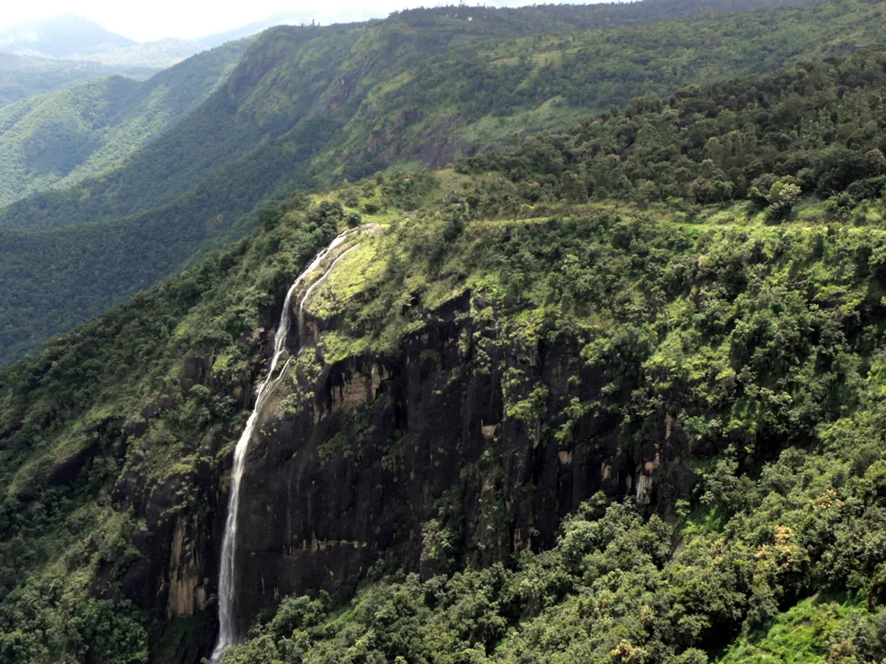
Crabtree Falls Trail
- Location: Blue Ridge Parkway, Milepost 339.5
- Distance: 2.5 miles loop
- Difficulty: Moderate
- Description: Descend through lush forest to a 70-foot waterfall, one of the most impressive in North Carolina. The trail features some steep sections and stairs, making it moderately challenging. The waterfall and surrounding greenery make it a photographer’s favorite[5].
- Highlights: Dramatic waterfall, wildflower displays, shaded forest hiking[5].
Graveyard Fields Loop
- Location: Blue Ridge Parkway, south of Asheville
- Distance: Varies (Lower Falls loop is easy; full loop is longer)
- Difficulty: Easy (Lower Falls) to Moderate (full loop)
- Description: The valley offers an easy, flat walk to Lower Falls, ideal for families. The full loop is more challenging, traversing rhododendron thickets and offering seasonal blueberries. Multiple waterfalls and boardwalks add to the scenic appeal[3].
- Highlights: Waterfalls, blueberries in late summer, accessible for beginners, colorful flora[3].
Lunch Rocks Trail
- Location: Blue Ridge Parkway, Milepost 382 (Folk Art Center)
- Distance: 4.9 miles round trip
- Difficulty: Moderate
- Description: Starting at the popular Folk Art Center, this hike follows the Mountains-to-Sea Trail to a rocky overlook with views of Haw Creek Valley. Despite being close to downtown, the trail feels remote and peaceful[1].
- Highlights: Convenient access, forested path, scenic overlooks[1].
Hard Times Loop
- Location: Blue Ridge Parkway, Milepost 395 (Bent Creek Experimental Forest)
- Distance: 6 miles round trip
- Difficulty: Easy to Moderate
- Description: Despite its name, this is one of the gentlest trails near Asheville. It loops through Bent Creek and the NC Arboretum, offering views of Lake Powhatan and mountain ridges. Suitable for most fitness levels[1].
- Highlights: Lake views, gentle terrain, botanical interest[1].
Fryingpan Mountain Lookout Tower
- Location: Blue Ridge Parkway, Milepost 409.6
- Distance: 1.5 miles round trip
- Difficulty: Easy to Moderate
- Description: A short but steep hike leads to a historic fire tower with 360-degree views. The tower’s height may challenge those afraid of heights, but the vistas are unparalleled[1].
- Highlights: Fire tower access, panoramic views, short but steep climb[1].
Additional Noteworthy Trails
- Catawba Falls Trail: Near Old Fort, south of Asheville, this easy hike follows the Catawba River to a beautiful waterfall. Side trails offer more adventure for those interested[3].
- Douglas Falls Trail: Part of the Craggy Gardens area, this 4-mile hike leads to a 70-foot waterfall and is suited for those seeking a longer, moderate trek[5].
- Linville Falls: Although farther from Asheville, this Blue Ridge Parkway classic (Milepost 316.3) offers several vantage points of a dramatic waterfall and gorge, with trails ranging from easy to strenuous[5].
Guided Hiking Options
For those preferring a guided experience, several companies offer tours along the Blue Ridge Parkway, including waterfall hikes and expert-led excursions that handle driving and navigation[2][4].
Summary Table
| Trail Name | Distance (Round Trip) | Difficulty | Highlights | |------------------------------|-----------------------|-----------------|-------------------------------------| | Craggy Pinnacle Trail | 1 mile | Easy–Moderate | 360° views, wildflowers | | Mount Pisgah Trail | 2.6 miles | Moderate–Strenuous | Summit views, iconic peak | | Crabtree Falls Trail | 2.5 miles | Moderate | Waterfall, forest scenery | | Graveyard Fields Loop | Varies | Easy–Moderate | Waterfalls, blueberries, boardwalk | | Lunch Rocks Trail | 4.9 miles | Moderate | Overlook, forest, easy access | | Hard Times Loop | 6 miles | Easy–Moderate | Lake, ridges, gentle terrain | | Fryingpan Mountain Lookout | 1.5 miles | Easy–Moderate | Fire tower, panoramic views | | Catawba Falls Trail | ~4 miles | Easy | Waterfall, riverside | | Douglas Falls Trail | 4 miles | Moderate | Waterfall, forest | | Linville Falls | Varies | Easy–Strenuous | Waterfall, gorge views |
Whether you’re a beginner or a seasoned hiker, Asheville’s trail network offers a rich variety of landscapes, vistas, and natural features, all within easy reach of the city[1][3][5].
Some additional trails worth mentioning include:
- Party Rock Trail: Offers a stunning view of Lake Lure and the mountains beyond, with a moderate difficulty, a distance of 2.3 miles, and an elevation gain of 895 feet. (Currently closed indefinitely)
- Rainbow Falls: A powerful, 150-foot waterfall that creates mist and rainbows on sunny days.
- Turtleback Falls: Offers a gentler cascade and a popular swimming hole when the weather's warm.
- Black Balsam Knob and Tennent Mountain: A scenic stretch of trail near Asheville, with a moderate difficulty, a distance of 3.7 miles, and an elevation gain of 784 feet.
- Catawba Falls: Has been reopened after improvements and is known for its multi-tiered waterfall.
- Looking Glass Rock: One of the most popular and challenging hikes near Asheville, with a hard difficulty, a distance of 5.6 miles, and an elevation gain of 1,679 feet.
- Cloudland Trail to Roan High Bluff: Offers a stunning view in the Roan Highlands.
- John Rock Loop: A great choice for mountain views without the crowds that usually come with them, with a moderate difficulty, a distance of 4.7 miles, and an elevation gain of 1,066 feet.
[1] Blue Ridge Parkway Association. (n.d.). Hiking Trails. Retrieved from https://www.blueridgeparkway.org/hiking-trails
[2] ExploreAsheville.com. (n.d.). Hiking & Waterfalls. Retrieved from https://www.exploreasheville.com/outdoor-recreation/hiking-waterfalls
[3] North Carolina Department of Natural and Cultural Resources. (n.d.). Hiking Trails. Retrieved from https://www.ncparks.gov/subject-areas/hiking
[4] WNC Hiking Guide. (n.d.). Best Hiking Trails in Asheville and Western North Carolina. Retrieved from https://wnc.com/hiking-trails/
[5] VisitNC.com. (n.d.). Hiking in North Carolina. Retrieved from https://www.visitnc.com/outdoor-adventure/hiking
- The Craggy Pinnacle Trail, located on the Blue Ridge Parkway (Milepost 364–367), offers panoramic views of the Blue Ridge Mountains after a short but steep hike through a tunnel of rhododendron, birch, and wildflowers.
- Mount Pisgah Trail, another Blue Ridge Parkway hike (Milepost 407.6), is a moderately to strenuous trail that ascends through forests to the 5,721-foot summit of Mount Pisgah, a landmark visible from downtown Asheville.
- The Crabtree Falls Trail, situated on the Blue Ridge Parkway (Milepost 339.5), is a moderate hike that descends through lush forest to a 70-foot waterfall, one of the most impressive in North Carolina.
- For beginners, the Graveyard Fields Loop, located south of Asheville on the Blue Ridge Parkway, offers an easy, flat walk to Lower Falls and a more challenging, seasonal hike through rhododendron thickets for a full loop.
- The Lunch Rocks Trail, starting at the popular Folk Art Center (Milepost 382), follows the Mountains-to-Sea Trail to a rocky overlook with views of Haw Creek Valley, despite being close to downtown Asheville.


